WSU AgWeatherNet: a tool to plan and manage farm operations
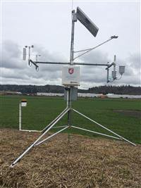
The new Chehalis weather station that is part of the WSU
AgWeatherNet system is a local resource for farmers and producers to plan and
track weather conditions for weed control treatments and other farm management practices.
The weather station was installed at the Chehalis Airport in
February, 2016 to provide current and historical weather data. The data can be observed from a mobile phone
or your desktop computer at http://weather.wsu.edu.
Air temperature, windchill, dewpoint, wind direction, wind
speed, soil temperature (2”, 8”), evapotranspiration, rain fall, relative
humidity, atmospheric pressure and solar radiation is the weather data recorded
on fifteen minute intervals.
The information can be easily viewed from the “Weather
Dashboard” at the website. WSU AgWeatherNet
data may be accessed and retrieved free of charge. Other nearby weather stations in the WSU
AgWeatherNet systems include: Tumwater, Montesano, Tokeland and Vancouver. Applications for mobile devices can be searched
(agweathernet) and downloaded from Google Play, The App Store or your favorite
mobile applications source.
WSU Lewis County Extension and the LC Noxious Weed Control
Board partnered with WSU AgWeatherNet to establish the weather station in
Chehalis. For more information about the
station or how you can support the maintenance of the local station contact the
Extension office at 360 740 1212.